

Bird Strike Committee Proceedings
Bird Strike Committee-USA/Canada Joint Annual Meeting: 8th (2006)
Accessibility Remediation
If you are unable to use this item in its current form due to accessibility barriers, you may request remediation through our remediation request form.
Date of this Version
August 2006
Document Type
Article
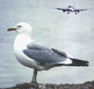
Abstract
The likely risk of a bird-aircraft collision (bird-strike) in a given airport was assessed using a standard methodological evaluation of birds along the runaway to record data and spatial distribution of danger; and making a threat categorization. Contiguous quadrants of 200 X 200 meters were located along the runaway from one head to the other with a center point count at 100 m, in which all birds were recorded for 15 minutes, accounting for species identification, number of individuals (flock size), flight altitude from ground to > 1,000 m, flight direction including number of perpendicular crosses, and behavioral characteristics (flight, roosting, foraging, reproduction and vocalizations as indicative of permanence and territoriality). Environmental data (% cloud cover and weather -sunny, partially sunny, mist or rainy-) was also recorded. The relative threat and likelihood to generate a collision by any bird species was taken as the result of the sum of scores of four criteria (each with three possible values): 1. Range of weight, 2. Relative abundance, 3. Relative crosses and 4. Flock size. Species were categorized as highly dangerous (10 to 12 score points), potentially dangerous and of concern (7 to 9), or of least danger but precautions warranted (< 6) for some species. Threat categorization and spatial distribution for each species allowed assessing areas of bird species concentrations, identification of sites more often crossed and if attracted by artificial or natural areas, as well as time of the day and climatic conditions that did so. Proposal of direct management options, tools and strategies for a bird avoidance program for specific airports is being developed by the Colombian Civil Aviation Agency -Aerocivil to ensure international air safety standards.