

Natural Resources, School of
Conservation and Survey Division: Faculty and Staff Publications
Accessibility Remediation
If you are unable to use this item in its current form due to accessibility barriers, you may request remediation through our remediation request form.
Document Type
Article
Date of this Version
Fall 2001
Citation
2001 Author
Abstract
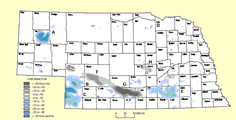
A data base collected over the last 100 years, containing both surface and subsurface information, has allowed us to begin to understand the physical framework of Nebraska. We have learned that even in the stable Midcontinent region of North America, there has been an active geologic history. This framework has been deciphered by our programs of surface geologic mapping and by the study of rock samples from both water wells and those deeper test wells for oil and gas. Determining the major structural features across the state (figure 1) has allowed us to better understand both the occurrences of its natural resources and natural hazards.
It has been a more difficult problem to explain the process by which this physical framework was established. The last 500 million years of our geologic history is recorded in sedimentary rock layers of sandstone, limestone and shale. These units record an active history of deposition, uplift and erosion. However, it is the older, crystalline igneous and metamorphic rocks of Precambrian age that control the zones of structural weakness across the state. Only by understanding the history of these much older "basement" rocks - their composition and their method of formation - can we explain the current architecture of our state and possibly anticipate where future activity might occur.
Included in
Geology Commons, Geomorphology Commons, Hydrology Commons, Paleontology Commons, Sedimentology Commons, Soil Science Commons, Stratigraphy Commons