

Natural Resources, School of
Conservation and Survey Division: Faculty and Staff Publications
Accessibility Remediation
If you are unable to use this item in its current form due to accessibility barriers, you may request remediation through our remediation request form.
Document Type
Report
Date of this Version
2003
Citation
Summerside, S.E. Vasek, R., Gosselin D.C., Jess, J.M. 2003. A Reconnaissance Scale Assessment of Confining Conditions within the Ground-water System of the Principal Aquifer in the Upper Big Blue NRD. University of Nebraska. pp. 14.
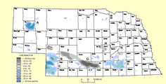
Map1, Ground-water Conditions.jpg (1667 kB)
Map2, Drawdown in Recorder Wells 1988 & 2002.jpg (1366 kB)
Map3, Continued Drawdown Data from Production Wells.jpg (2878 kB)
Map4, Contoured Transmissivity Data.jpg (2329 kB)
Map5, Percentage of Sediments Silt & Clay.jpg (2126 kB)
Map6, Total Thickness Clay & Silt Above Bedrock.jpg (2085 kB)
Map7, Thickness Silt & Clay Above Main Aquifer.jpg (2162 kB)
Map8, Pressure Head Above Main Aquifer.jpg (2034 kB)
Map9, Confined Aquifer & Well Interference.jpg (935 kB)
Included in
Geology Commons, Geomorphology Commons, Hydrology Commons, Paleontology Commons, Sedimentology Commons, Soil Science Commons, Stratigraphy Commons
Comments
OFR-99