

Natural Resources, School of
Conservation and Survey Division: Faculty and Staff Publications
Accessibility Remediation
If you are unable to use this item in its current form due to accessibility barriers, you may request remediation through our remediation request form.
Document Type
Fact Sheet
Date of this Version
2024
Citation
Shrestha, Nawaraj. 2024. 2003 Wetlands in the Nebraska Sandhills. Conservation and Survey Division
Abstract
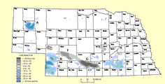
Infographic titled “Status of Wetlands in the Nebraska Sandhills” showing multiple maps and charts. The top left features a color-coded wetland persistence map where blue indicates more consistent wetlands and red indicates intermittent wetlands. Additional inset maps show a regional zoom and a U.S. location map highlighting Nebraska. A large scatter plot displays wetland occurrence percentages over time using MODIS (green points) and Sentinel (blue points) satellite data from 2000 to 2024. Text explains how wetlands vary seasonally and annually and how satellite imagery tracks these changes. A smaller bottom chart shows long-term wetland trends, noting increasing occurrence since 1984. The infographic includes explanatory text about satellite resolution and the importance of understanding wetland dynamics. Infographic titled “Wetlands in the Nebraska Sandhills” explaining what wetlands are and their importance. The layout includes text sections describing wetlands as productive ecosystems and noting historical loss in the United States. A chart shows wetland area loss over decades. Another section explains that the Sandhills contain about 3.7 million acres of wetlands and describes factors affecting them such as precipitation, temperature, soil moisture, and management practices. Three satellite images compare a wet year (July 2010), dry year (July 2012), and normal year (July 2022). The bottom section highlights benefits of wetlands like flood control and wildlife habitat, with icons showing percentages of species relying on wetlands. A QR code and contact information for a conservation program appear in the lower right.
Included in
Geology Commons, Geomorphology Commons, Hydrology Commons, Paleontology Commons, Sedimentology Commons, Soil Science Commons, Stratigraphy Commons
Comments
ESN-13