

Drought Mitigation Center, United States National
National Drought Mitigation Center: Faculty Publications
Accessibility Remediation
If you are unable to use this item in its current form due to accessibility barriers, you may request remediation through our remediation request form.
Document Type
Article
Abstract
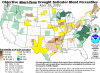
The vegetation drought response index (VegDRI), which combines traditional climate- and satellite-based approaches for assessing vegetation conditions, offers new insights into assessing the impacts of drought from local to regional scales. In 2011, the U.S. southern Great Plains, which includes Texas, Oklahoma, and New Mexico, was plagued by moderate to extreme drought that was intensified by an extended period of recordbreaking heat. The 2011 drought presented an ideal case study to evaluate the performance of VegDRI in characterizing developing drought conditions. Assessment of the spatiotemporal drought patterns represented in the VegDRI maps showed that the severity and patterns of the drought across the region corresponded well to the record warm temperatures and much-below-normal precipitation reported by the National Climatic Data Center and the sectoral drought impacts documented by the Drought Impact Reporter (DIR). VegDRI values and maps also showed the evolution of the drought signal before the Las Conchas Fire (the largest fire in New Mexico’s history). Reports in the DIR indicated that the 2011 drought had major adverse impacts on most rangeland and pastures in Texas and Oklahoma, resulting in total direct losses of more than $12 billion associated with crop, livestock, and timber production. These severe impacts on vegetation were depicted by the VegDRI at subcounty, state, and regional levels. This study indicates that the VegDRI maps can be used with traditional drought indicators and other in situ measures to help producers and government officials with various management decisions, such as justifying disaster assistance, assessing fire risk, and identifying locations to move livestock for grazing.
Included in
Climate Commons, Environmental Indicators and Impact Assessment Commons, Environmental Monitoring Commons, Hydrology Commons, Other Earth Sciences Commons, Water Resource Management Commons
Comments
OPEN ACCESS