

Drought Mitigation Center, United States National
National Drought Mitigation Center: Faculty Publications
Accessibility Remediation
If you are unable to use this item in its current form due to accessibility barriers, you may request remediation through our remediation request form.
Document Type
Article
Date of this Version
2008
Citation
GIScience & Remote Sensing, 2008, 45, No. 1, p. 16–46.
DOI: 10.2747/1548-1603.45.1.16
Abstract
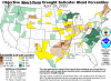
The development of new tools that provide timely, detailed-spatial-resolution drought information is essential for improving drought preparedness and response. This paper presents a new method for monitoring drought-induced vegetation stress called the Vegetation Drought Response Index (VegDRI). VegDRI integrates traditional climate-based drought indicators and satellite-derived vegetation index metrics with other biophysical information to produce a 1 km map of drought conditions that can be produced in near-real time. The initial VegDRI map results for a 2002 case study conducted across seven states in the north-central United States illustrates the utility of VegDRI for improved large-area drought monitoring.
Included in
Climate Commons, Environmental Indicators and Impact Assessment Commons, Environmental Monitoring Commons, Hydrology Commons, Other Earth Sciences Commons, Water Resource Management Commons
Comments
U.S. government work