

Natural Resources, School of
Conservation and Survey Division: Faculty and Staff Publications
1985
Annual Outflow of Water From Nebraska, 1950 - 1985 and Annual Inflow of Water To Nebraska, 1950 - 1985, Conservation and Survey Division
Keith County, Nebraska, Map Series, Robert F. Diffendal Jr., Mark S. Kuzila, J. R. Culver, Harold M. DeGraw, R. R. Burchett, M. P. Carlson, T. Eversoll, William D. Gosnold, and Nebraska Geological Survey
Annual Outflow of Water from Nebraska, 1950-1984, Conservation Survey Division
Significant Rises and Declines in Nebraska Groundwater Levels (from Pre-Development as of Fall 1984)/Registered Irrigation Wells in Nebraska (as of January 1, 1985, Conservation Survey Division and U.S. Geological Survey
Atlas Illustrating the Characteristics of Groundwater in Nebraska, Vince Dreeszen
Groundwater Levels in Nebraska 1984, Michael J. Ellis and Darryll T. Pederson
Groundwater Levels in Nebraska, 1984, Michael J. Ellis and Darryll T. Pederson
Concentration of Nitrate-Nitrogen in Groundwater Central Platte Region, Nebrask 1984, M. E. Exner
The Amphibians and Reptiles of Nebraska, George E. Hudson
Thermal Infrared Remote Sensing of Near-Surface Moisture: A Case Study in the Nebraska Sandhills, L. P. Queen, D. C. Rundquist, and M. P. Lawson
Airborne Thermal Mapping of a "Flow-Through" Lake in the Nebraska Sandhills, Donald Rundquist, Gene Murray, and Lloyd Queen
1984
1984 County Gravity Survey, Complete Gravity Listings, Raymond R. Burchett
Nebraska Mineral Operations Review, 1983, Raymond R. Burchett and Duane A. Eversoll
Annual Departures from Average Annual Precipitation in Nebraska, 1850-1983, Conservation and Survey Division
Annual Departures from Average Annual Precipitation in Nebraska, 1850-1983, Conservation Survey Division
Annual Departures from Average Annual Precipitation in Nebraska, 1850-1983, Conservation Survey Division
Annual Installation of Irrigation Wells in Nebraska Through 1983, Conservation Survey Division
Annual Outflow of Water from Nebraska, 1950-1983, Conservation Survey Division
Groundwater Levels in Nebraska, 1983, Martin S. Johnson and Darryll T. Pederson
Inventory of Irrigation Water Use Box Butte County, Nebraska 1981, Dennis R. Lawton and Larry L. Teahon
Dakota Aquifers in Eastern Nebraska, Aspects of Water Quality and Use, D. R. Lawton, O. Goodenkauf, B. V. Hanson, and F. A. Smith
Inventory of Irrigation Water Use in Box Butte County, Nebraska 1981, D. R. Lawton and L. L. Leahon
Geology of Ponca State Park, Nebraska, Roger K. Pabian and Dennis R. Lawton
1983
Monitoring Nebraska's Sandhills Lakes, D. W. Buckwalter
Nebraska Mineral Operations Review, 1982, Raymond R. Burchett and Duane A. Eversoll
Forest City Basin Map: Bouguer Gravity Anomaly Map, R. R. Burchett, R. R. Anderson, L. L. Brady, and K. L. Deason
Forest City Basin Map: Deep-well, Oil-field, and Gas-well Location Map, R. R. Burchett, R. R. Anderson, L. L. Brady, and K. L. Deason
Forest City Basin Map: Magnetic Map, R. R. Burchett, R. R. Anderson, L. L. Brady, and K. L. Deason
Forest City Basin Map: Mineral Resource Map, R. R. Burchett, R. R. Anderson, L. L. Brady, and K. L. Deason
Forest City Basin Map: Precambrian Configuration Map, R. R. Burchett, R. R. Anderson, L. L. Brady, and K. L. Deason
Forest City Basin Maps: Lineament Map, R. R. Burchett, R. R. Anderson, L. L. Brady, and K. L. Deason
Forest City Basin Map: Structural Contour Map of the Kansas City (Pennsylvanian), R. R. Burchett, R. R. Anderson, L. L. Brady, and K. L. Deason
Annual Departures from Average Annual Precipitation in Nebraska, 1850-1982, Conservation and Survey Division
Annual Departures from Average Annual Precipitation in Nebraska, 1850-1982, Conservation Survey Division
Hydrogeology of Butler County, Nebraska, Marilyn H. Ginsberg
Groundwater Levels in Nebraska, 1982, Martin S. Johnson and Darryll T. Pederson
An Inventory of Public, Industry, and Power-generating Water Use in Nebraska, 1979 and 1980, Dennis R. Lawton, Cynthia L. Veys, and Owen Goodenkauf
Wetland Inventories of Nebraska's Sandhills, D. C. Rundquist
Bibliography of Nebraska Geology, 1843-1976, John H. Sandy and Jay Fussell
Policy Issue Study on Supplemental Water Supplies, Clinton VonSeggern and Bob Kuzelka
1982
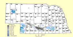
Nebraska Groundwater Level (Decline & Rise) and Location of Registered Wells, 1982
Nebraska Groundwater Level (Decline & Rise) and Location of Registered Wells, 1983
Nebraska's Platte River: A Graphic Analysis of Flows, Ray Bentall
Nebraska Mineral Operations Review, 1982, Raymond R. Burchett and Duane A. Eversoll
Thickness and Structure Maps of the Pennsylvanian and Permian Rocks Across Southern Nebraska, R. R. Burchett
Geothermal Resources of Nebraska, W. D. Gosnold and D. A. Eversoll
Groundwater Levels in Nebraska, 1981, Martin S. Johnson and Darryll T. Pederson
1981
Nebraska Groundwater Level (Decline & Rise) and Location of Registered Wells, 1981
Development of Irrigation Well Drilling in Nebraska, Vance Anderson
Nebraska Mineral Operations Review, 1980, Raymonds R. Burchett and Duane A. Eversoll
Regional Tectonics and Seismicity of Eastern Nebraska, Annual Report, July 1979–June 1980, R. R. Burchett
Regional Tectonics and Seismicity of Eastern Nebraska, Annual Report, July 1980–June 1981, R. R. Burchett
Annual Outflow of Water from Nebraska, 1950-1980, Conservation Survey Division
Nebraska Mineral Operations Review, 1980, D. A. Eversoll and R. R. Burchett
Groundwater Levels in Nebraska, 1980, Martin S. Johnson and Darryll T. Pederson
Geology and Groundwater Supplies of Southern Dawes and Northern Sheridan Counties, Nebraska, Vernon L. Souders
1980
Nebraska Groundwater Level (Decline & Rise) and Location of Registered Wells, 1980
Collecting in Nebraska's Glacial Deposit, John Boellstorff
Nebraska Mineral Operations Review, 1979, Raymond R. Burchett and Duane A. Eversoll
Configuration of the Base of the Principal Aquifer, Conservation and Survey Division, University of Nebraska-Lincoln
Collecting in Nebraska's Cretaceous Strata, H. M. DeGraw and R. K. Pabian
Ash Hollow Historical Park, Robert F. Diffendal Jr.
Annual Departures from Average Annual Precipitation in Nebraska, 1850-1979, Conservation Survey Division
Groundwater Levels in Nebraska, 1979, Martin S. Johnson and Darryll T. Pederson
Groundwater Levels in Nebraska, 1979, Martin S. Johnson and Darryll T. Pederson
Climate of Nebraska, Richard E. Myers
Geology Along the Republican River Valley Near Red Cloud, Nebraska, R. K. Pabian and J. B. Swinehart
Geology and Groundwater Supplies of Box Butte County, Nebraska, 1979, V. L. Souders, F. A. Smith, and J. B. Swinehart
Configuration of Base of Principal Aquifer, 1979 Fremont and Omaha Quadrangle, Nebraska, Conservation and Survey Division
The Process and Criteria for Siting of Hazardous Waste Disposal Facilities in Nebraska, Conservation and Survey Division
Configuration of Base of Principal Aquifer, 1979 Grand Island Quadrangle, Nebraska, Conservation and Survey Division and Environmental Control
Collecting in Western Nebraska's Cenozoic Strata, J. B. Swinehart
1979
Nebraska Groundwater Level (Decline & Rise) and Location of Registered Wells, 1979
Availability and Use of Water in Nebraska, 1975, R. Bentall and F. B. Shaffer
Nebraska Mineral Operations Review, 1978, Raymond R. Burchett and Duane A. Eversoll
The Mississippian and Pennsylvanian (Carboniferous) Systems in the United States-Nebraska, R. R. Burchett
Interpretive Study and Numerical Model of the Hydrogeology Upper Big Blue Natural Resources District., Ralph E. Cady and Marilyn H. Ginsberg
Inferred Areal Extent of the Oligocene (White River Group) Chadron Basal Sand, Conservation and Survey Division, University of Nebraska-Lincoln
Pre-Tertiary Subcrop Rocks in the Nebraska Panhandle, Conservation and Survey Division, University of Nebraska-Lincoln
Geologic History of Scotts Bluff National Monument, Roger K. Pabian and James B. Swinehart III
Groundwater Levels in Nebraska, 1978, Darryll T. Pederson and Martin S. Johnson
Groundwater Levels in Nebraska, 1978, Darryll T. Pederson and Martin S. Johnson
Tree Root Systems In Eastern Nebraska, John A. Sprackling and Ralph A. Read
Tree Root Systems In Eastern Nebraska, John A. Sprackling and Ralph A. Read
1978
Nebraska Groundwater Level (Decline & Rise) and Location of Registered Wells, 1978
A Need for Redefinition of North American Pleistocene Stages, J. D. Boellstorff
Nebraska Mineral Operations Review, 1977, Raymond R. Burchett and Duane A. Eversoll
Regional Tectonics and Seismicity of Eastern Nebraska, Annual Report June 1, 1978- May 30, 1979, R. R. Burchett
Structure of the Tarkio Limestone Along the Humboldt Fault Zone in Southeast Nebraska, R. R. Burchett and J. L. Arrigo
Groundwater Levels in Nebraska, 1977, Michael J. Ellis and Darryll T. Pederson
Groundwater Levels in Nebraska, 1977, Michael J. Ellis and Darryll T. Pederson
Water Resources of Seward County, Nebraska, C. F. Keech
Tertiary Stratigraphy of the Niobrara River Valley, Marsland Quadrangle, Western Nebraska, Conservation and Survey Division
1977
Nebraska Groundwater Level (Decline & Rise) and Location of Registered Wells, 1977
Water Resources Data for Nebraska Water Year 1976
Nebraska Mineral Operations Review, 1976, Raymond R. Burchett and Duane A. Eversoll
Coal Resources of Nebraska, R. R. Burchett