

Natural Resources, School of
Conservation and Survey Division: Faculty and Staff Publications
1969
New Members of the Gering Formation (Miocene) in Western Nebraska, Including a Geological Map of Wildcat Ridge and Related Outliers, Carl F. Vondra, C. Bertrand Schultz, and Thompson M. Stout
1968
Acres Irrigated in Nebraska- Past and Present
Nebraska Groundwater Level (Decline & Rise), 1968
Description of Nebraska's Common Rocks, Raymond Burchett
Directory of Nebraska Quarries, Pits and Mines (1968), R. R. Burchett
Water Levels In Observation Wells In Nebraska, 1967, C.F. Keech
Groundwater Data Polk County, Nebraska, F.A. Smith and E.C. Weakly
1967
Nebraska Groundwater Level (Decline & Rise), 1967
Centennial Guidebook to the Geology of Southeastern Nebraska, R. R. Burchett and E. C. Reed
Centennial Guidebook to the Geology of Southeastern Nebraska, R. R. Burchett and E. C. Reed
Stratigraphic Chart of the Waubansee Group in Nebraska, R. R. Burchett and E. C. Reed
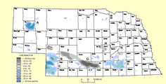
Precambrian Well Data in Nebraska, Including Rock Type and Surface Configuration, Marvin P. Carlson
Early Silurian Brachiopods from the Subsurface of Southeastern Nebraska, M. P. Carlson and A. J. Boucot
Early Silurian Brachiopods from the Subsurface of Southeastern Nebraska, M. P. Carlson and A. J. Boucot
Devonian of the North-Central Region, United States, C. Collinson and Marv Carlson
The Nitrate Hazard In Well Water: With Special Reference To Holt County, Nebraska., Richard A. Engberg
Water Levels In Observation Wells In Nebraska, 1966, C.F. Keech
Stratigraphic Cross Section of Paleozoic Rocks of Nebraska, Russell Smith and Raymond Burchett
1966
Total Number of Irrigation Wells Located in Nebraska Counties as of 1966
Twelve Maps Summarizing the Geologic Framework of Southeastern Nebraska, R. R. Burchett and M. P. Carlson
Water Levels in Observation Wells in Nebraska, 1965, Philip A. Emery and Mildred M. Malhoit
Evidence of Multiple Glaciation in the Glacial - Periglacial Area of Eastern Nebraska, E. C. Reed, V. H. Dreeszen, J. V. Drew, V. L. Souders, J. A. Elder, and J. D. Boellstorff
Availability and Use of Water in Nebraska, F. Butler Shaffer
1965
Total Number of Irrigation Wells Located in Nebraska Counties as of 1965
Correlation of Formations Drilled in Test Holes for Interstate 480 Bridge between Omaha, Nebraska, and Council Bluffs, Iowa, R. R. Burchett
Water Levels in Observation Wells in Nebraska, 1964, Philip A. Emery and Mildred M. Malhoit
Nebraska's Groundwater, C. First, J. Kufel, and M. Seidel
Nebraska's Groundwater, C. First, J. Kufel, and M. Seidel
Relationships Oct-Nov 1965 Observation Well Measurements to Median Observed Ground Water Levels, E. C. Reed
Revision of the Classification of the Pleistocene Deposits of Nebraska, E. C. Reed and V. H. Dreeszen
International Association for Quaternary Research VIIth Congress-Guidebook for Field Conference D, Central Great Plains, Bertrand C. Schultz and H.T.U. Smith
1964
Nebraska Groundwater Level Map (Decline & Rise) between Fall 1954 and Fall 1964
Nebraska Soils, John A. Elder
Basic-Data Report Saline County, Nebraska, Philip A. Emery
Water Levels in Observation Wells In Nebraska, 1963, Philip A. Emery and Mildred M. Malhoit
Basic-Data Report York County, Nebraska, C.F. Keech
Stratigraphic Sequences in the Pennsylvanian of Nebraska and Their Relationships to Cyclic Sedimentation, E. C. Reed and R. R. Burchett
1963
Nebraska Groundwater Level Map (Decline & Rise), Fall 1963
Lithostratigraphy and Correlation of the Mississippian System in Nebraska, Marvin P. Carlson
Topographic Regions Maps, J. A. Elder, V. H. Dreeszen, and E. C. Weakly
Water Levels In Observation Wells In Nebraska, 1962, Philip A. Emery and Mildred M. Malhot
1962
The Program of Ground- Water Investigations In Nebraska, C.F. Keech
Water Levels In Observation Wells In Nebraska, 1961, C.F. Keech and J.B. Hyland
Groundwater Map of Nebraska Relation Fall 1962 Observation Well Readings to Median, E. C. Reed
1961
Basic Data Report Lower Cedar River Drainage Basin, Nebraska, J.B. Hyland
Water Levels in Observation Wells in Nebraska 1960, C.F. Keech
Groundwater Map of Nebraska Showing Relation of Fall 1961 Readings to Median Water Level Management, E. C. Reed
1960
Water Levels in Observation Wells in Nebraska, 1959, C. F. Keech
Wells in Fillmore County, Nebraska, C.F. Keech
Wells in Hamilton County, Nebraska, C.F. Keech
Groundwater Map of Nebraska, November 1960, E. C. Reed and V. H. Dreeszen
1959
Water Levels in Observation Wells in Nebraska, 1958, C. F. Keech
The Geological Section of Nebraska, E. C. Reed
Boone County Preliminary Ground Water Study 1959 (GM-14): Svoboda, G.R. Conservation and Survey Division , size 8.5" X 11"., G.R. Svoboda
1958
Nebraska Groundwater Relation to Median, Fall 1958
Total Number of Irrigation Wells Located in Nebraska Counties as of 1958
Photograph of Relief Model Map of Nebraska, Conservation and Survey Division
Water Levels in Observation Wells in Nebraska, 1957, C. F. Keech
Groundwater Map of Nebraska Showing Relation of Fall 1959 Readings to Median Water Level Measurement, E. C. Reed
1957
Log of Test Holes Frenchman Creek Basin Nebraska, C. F. Creech
Nebraska Groundwater Level (Decline & Rise) as of December 1957., E. C. Reed
Preliminary estimate of the underflow across the South Dakota-Nebraska State line in the Niobrara River and Ponca Creek drainage basins, E. C. Reed and C. F. Keech
1956
Annual Installation of Irrigation Wells in Nebraska Through 1985, Conservation Survey Division
1955
Relation of Nebraska Water-level Measurements Made in 1955 to Median Water-level Position, E. C. Reed
1954
Occurrence of Great Soil Groups in Nebraska, J. A. Elder
1953
Industrial Nebraska in Outline (Revised), G. E. Condra
Log of Test Holes Deuel and Garden Counties Nebraska, C. F. Keech and R. L. Schreurs
1952
Origin and Scope of the Conservation Program, G. E. Condra
Departmental Functions of the Conservation and Survey Division, G. E. Condra and E. C. Reed
1951
The Red Cloud Sand and Gravel, a New Pleistocene Formation in Nebraska, C. Bertrand Schultz, Eugene C. Reed, and A. L. Lugn
1950
Generalized Soil Map of Nebraska
A Subsurface Study of the Pleistocene Deposits in Kearney County and Adjoining Parts of Adams, Franklin, and Webster Counties (Includes Text Analyses and Thesis Material), Vincent H. Dreeszen
Areas in Nebraska of Subirrigated Vegetation, John Elder
1948
Progress of Fundamental Survey in Nebraska, G. E. Condra
Ground-Water Levels in the Lower Platte River Valley, Nebraska, H. A. Waite
Ground-Water Levels in the Lower Platte River Valley, Nebraska, H. A. Waite
1947
The Integration of Water Use in Nebraska, G. E. Condra
Nuckolls County Preliminary Ground Water Study 1947 and 1948, E.C. Reed
1946
Industrial Nebraska in Outline, G. E. Condra
1945
Land and Water Conservation Problems of the Missouri River Basin, G. E. Condra
Ground Water In The Republican River Basin In Nebraska-Part III: Red Willow and Frontier Counties, H.A. Waite, E.C. Reed, and D.S. Jones Jr.
Ground Water In The Republican River Basin In Nebraska-Part IV: Hitchcock, Hayes, Dundy and Chase Counties, H.A. Waite, E.C. Reed, and D.S. Jones Jr.
1944
Drought, Its Effects and Measures of Control in Nebraska, G. E. Condra
Terminology Relating to the Occurrence, Behavior and Use of Water in Nebraska, G. E. Condra
Groundwater Survey of Area North of O'Neill, Holt County, Nebraska, E. C. Reed
Ground Water In The Republican River Basin in Nebraska- Part 1: Nuckolls, Webster, Franklin and Harlan Counties, H.A. Waite, E.C. Reed, and D.S. Jones Jr.
Ground Water in the Republican River Basin- Part II: Furnas County, H.A. Waite, E.C. Reed, and D.S. Jones Jr.
1942
Vegetation of the Northern Part of Cherry County, Nebraska, William L. Tolstead
1941
1940
Precambrian Rock Descriptions from Deep Wells in Nebraska, E. Liedecke
1939
Upper Carboniferous Formations in the Lower Platte Valley, G. E. Condra and O. J. Scherer
Correlation of the Amerada Petroleum Company Well Drilled near Nehawka, Nebraska, E. C. Reed and G. E. Condra
Deep Wells at Lincoln, Nebraska, E. C. Reed and G. E. Condra
1938
The Redfield Anticline of Nebraska and Iowa, G. E. Condra and E. C. Reed
Cheese Production in Nebraska. University of Nebraska, Walter Kollmorgen
Ice Cream Production in Nebraska., Walter Kollmorgen