

Natural Resources, School of
Conservation and Survey Division: Faculty and Staff Publications
1977
Greeley County, Chalk Mine State Wayside Area, R. K. Pabian
Jefferson County , Fairbury Area, R. K. Pabian
Jefferson County , Fairbury Area, R. K. Pabian
Pawnee County, Table Rock Area, R. K. Pabian
Sarpy County, Gretna State Fish Hatchery Area, R. K. Pabian
Sarpy County, Gretna State Fish Hatchery Area (Schramm Park), R. K. Pabian
Thayer County, Alexandria and Gilead Areas, R. K. Pabian
Thayer County, Alexandria and Gilead Areas, R. K. Pabian
1976
Location of Registered Irrigation Wells in Nebraska as of 1976
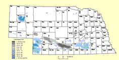
Nebraska Groundwater Level (Decline & Rise) and Location of Registered Wells, 1976
Water Resources Data for Nebraska Water Year 1975
Water Resources of Pierce County, Nebraska, Robert E. Brogden and Richard A. Engberg
Nebraska Mineral Operations Review, 1975, Raymond R. Burchett and Duane A. Eversoll
Regional Tectonics and Seismicity of Eastern Nebraska, Annual Report June 1, 1976- June 1, 1977, R. R. Burchett
Groundwater Levels in Nebraska, 1975, Michael J. Ellis and Darryll T. Pederson
Minerals and Gemstones of Nebraska: A Handbook for Students and Collectors, Roger K. Pabian and Allan Cook
Nebraska Remote Sensing Center News, Rex Peterson and Paul Seevers
Physiography, Geology, and Water Resources of Boyd County, Nebraska, Vernon L. Souders
LAWS, RULES, AND REGULATIONS PERTAINING TO GROUNDWATER IN NEBRASKA, Gerald R. Svoboda
1975
Location of Registered Irrigation Wells in Nebraska as of 1975
Nebraska Groundwater Level (Decline & Rise), 1975
1974 Nebraska Mining Operations Review, R R. Burchette
Groundwater Levels in Nebraska, 1974, M.J. Ellis
Meet Your Earthwatching Task Force, Jay Fussell
The Mineral Industry of Nebraska, William F. Keyes and Raymond R. Burchett
Collecting Nebraska's Colorful Agates, Roger K. Pagian
Remote Sensing, Rex Peterson
Groundwater Geology of Banner County, Nebraska, Frank A. Smith and Vernon L. Souders
Effects of Land Use and River Seepage on Groundwater Quality in Hall County, Nebraska, Roy F. Spalding
1974
Geology Tour of Lancaster County, Nebraska
Location of Registered Irrigation Wells in Nebraska as of 1974
Nebraska Groundwater Level (Decline & Rise), 1974
Total Number of Irrigation Wells Located in Nebraska Counties as of 1974
Spotlight on Mineral Stamps, R. R. Burchett
Inventory of Mining Operations in Nebraska, R. R. Burchett and Duane A. Eversoll
Geology Tour of Lancaster County, Nebraska, Conservation Survey Division
Groundwater Levels in Nebraska, 1973, M.J. Ellis
Predicted Water-Level Declines for Alternative Groundwater Developments in the Upper Big Blue River Basin, Nebraska, P. W. Huntoon
Groundwater Geology of Southwest Nebraska Ground Water Conservation District, Guy J. Leonard and Peter W. Huntoon
Guidebook to the 1974 Spring Field Trip of the Nebraska Geological Society, G.R. Svoboda
1973
Nebraska Groundwater Level (Decline & Rise), 1973
Total Number of Irrigation Wells Located in Nebraska Counties as of 1973
Water Resources Data for Nebraska Part 2-Water Quality Records
The Pierre-Niobrara Unconformity In Western Nebraska, Harold M. DeGraw
Groundwater Levels in Nebraska, 1972, M.J. Ellis
Selenium in Nebraska's Groundwater and Streams, R.A. Engberg
Evaluation of Nitrate Content of Ground Water in Hall County, Nebraska, Rauf Piskin
1972
Location of Registered Irrigation Wells in Nebraska as of 1972
Nebraska Groundwater Level (Decline & Rise), 1972
Total Number of Irrigation Wells Located in Nebraska Counties as of 1972
Interbasin Water Transfers and Groundwater Regulation in Nebraska, D. D. Axthelm, V. H. Dreeszen, and C. A. Lewis
Upper Pennsylvanian Shoreline Deposits form Iowa and Nebraska: Their Recognition, Variation, and Significance, J. A. Fagerstrom and R. R. Burchett
Groundwater Levels in Nebraska, 1971, C.F. Keech
Cass County, Weeping Water, R. K. Pabian
Late Paleozoic Trilobites from Southeastern Nebraska, R. K. Pabian and J. A. Fagerstrom
Statewide Precipitation and Discharge of Platte River above Ashland, Bryce B. Pease
Availability and Use of Water in Nebraska, 1970, F. Butler Shaffer
Use of Groundwater for Irrigation in Clay County, Nebraska, 1970, Eugene K. Steele Jr.
1971
Nebraska Groundwater Level (Decline & Rise), 1971
Shaded Topographic Map Of Nebraska
Directory of Nebraska Quarries, Pits, and Mines, R. R. Burchett
Guidebook to the Geology Along Portions of the Lower Platte River Valley and Weeping Water Valley of Eastern Nebraska, R. R. Burchett
Shaded Topographic Map of Nebraska, Conservation and Survey Division
Nebraska Minimum Standards for Artificially Gravel Packed Irrigation Wells, P. E. Fischbach, P. E. Schleusener, and V. H. Dreeszen
Geologic and Water-Supply Reports and Maps, Nebraska, United States Dept. of the Interior
Groundwater Levels in Nebraska, 1970, C.F. Keech
Dunes on the Plains, The Sand Hills Region of Nebraska, C. F. Keech and R. Bentall
Occurrence of Groundwater in Kimball County, Nebraska: Including Logs of Test Holes, Frank A. Smith and Vernon L. Souders
Use of Groundwater for Irrigation in 1970: Hamilton and York Counties, Ne, Eugene K. Steele Jr.
Use of Groundwater for Irrigation in Hamilton and York Counties, Nebraska, Eugene K. Steele Jr.
Guidebook to the Late Pliocene and Early Pleistocene of Nebraska, T. M. Stout, H. M. DeGraw, L. G. Tanner, K. O. Stanley, W. J. Wayne, and J. B. Swinehart
1970
Groundwater Regions in Nebraska
Nebraska Groundwater Level (Decline & Rise), 1970
Total Number of Irrigation Wells Located in Nebraska Counties as of 1970
Guidebook to the Geology Along the Missouri River Bluffs of Southeastern Nebraska and Adjacent Areas, R. R. Burchett
Occurrence of Gypsum in the Johnson Shale (Permian) in Nemaha County, Nebraska, R. R. Burchett
Distribution and Subdivision of Precambrian and Lower and Middle Paleozoic Rocks in the Subsurface of Nebraska, M. P. Carlson
The Stratigraphic Framework of Pleistocene Glacial and Periglacial Deposits in the Central Plains, V. H. Dreeszen
Use of Groundwater for Irrigation: Seward County, Nebraska, J.M. Jess
Use of Groundwater for Irrigation: Seward County, Nebraska, J.M. Jess
Groundwater Levels in Nebraska, 1969, C.F. Keech
Record in Rock: A Handbook of the Invertebrate Fossils of Nebraska, Roger K. Pabian
Re-exploring the Missouri, Thompson Mylan Stout
1969
Nebraska Groundwater Level (Decline & Rise), 1969
Total Number of Irrigation Wells Located in Nebraska Counties as of 1969
Late Middle Ordovician Graptolites From the Subsurface of Eastern Nebraska, M. P. Carlson and W. B.N. Berry
Nebraska Soil Association Map, 1969, Conservation and Survey Division
Lancaster County, Nebraska Soils -- Geology Field Trip, Conservation Survey Division
Ground Water Atlas of Nebraska (June 1969), V. H. Dreeszen, J. A. Elder, E. C. Weakly, E. C. Reed, and G. R. Svoboda
Soils of Nebraska, John A. Elder
Groundwater Levels in Nebraska, 1969, C. F. Keech
Water Levels In Observation Wells In Nebraska, 1968, C.F. Keech and G.R. Svoboda
The Tiger's Back "A Report on Australian Organizations for Metropolitan Planning Administration", Robert D. Kuzelka
Otoe County, Unadilla. Lincoln: University of Nebraska, R. K. Pabian
Jefferson County, Fairbury Area, Conservation and Survey Division
New Members of the Gering Formation (Miocene) in Western Nebraska, Including a Geological Map of Wildcat Ridge and Related Outliers, Carl F. Vondra, C. Bertrand Schultz, and Thompson M. Stout
1968
Acres Irrigated in Nebraska- Past and Present
Nebraska Groundwater Level (Decline & Rise), 1968